Contents
- 1 GPS Devices and Apps: Why I Depend on Them for Hunting
- 2 Pre-Season Scouting and Hunt Planning
- 3 Staying Safe and Found in the Field
- 4 Hunting Features That I Use Most
- 5 Tips for Using GPS and Hunting Apps Safely
- 6 Common Questions About Hunting GPS and Hunting Apps
- 7 Best Practices for Consistent Hunting Success
Over the years, I’ve found that GPS devices and hunting apps make my hunts more efficient, help me steer through the wild without getting lost, and keep me much safer in remote areas. Reliable navigation and planning are really important for hunters, especially when moving through unfamiliar terrain or large properties. Today’s tech allows for precise digital maps, live weather, and handy location sharing, making solo and group hunts much smoother than ever before.
QUICK LOOK: Key Features of GPS and Hunting Apps
- Offline Maps: I always keep maps of my hunting spots saved locally. Signal loss is no big deal, and I never worry about getting turned around.
- Waypoints: I use waypoints for stand locations, game trails, waterholes, and travel corridors. Returning to these places—even at night—is simple.
- Terrain Layers: Lots of apps include elevation and topographic maps, plus solar angles. They help me picture how animals might move and where to expect wind shifts as the sun rises or sets.
- Property Lines: Avoiding trespass is important, so the detailed boundary info in hunting apps gives me the peace of mind that I’m respecting the rules and neighboring landowners.
- Weather and Wind: Built-in weather feeds show me current wind and changes in conditions, key for picking my setup and approaching quietly.
- Dog Tracking: For bird and raccoon hunting with my dog, GPS collars and synced apps help me keep tabs on my dog’s location, even when I can’t hear the bell in thick woods.
GPS Devices and Apps: Why I Depend on Them for Hunting
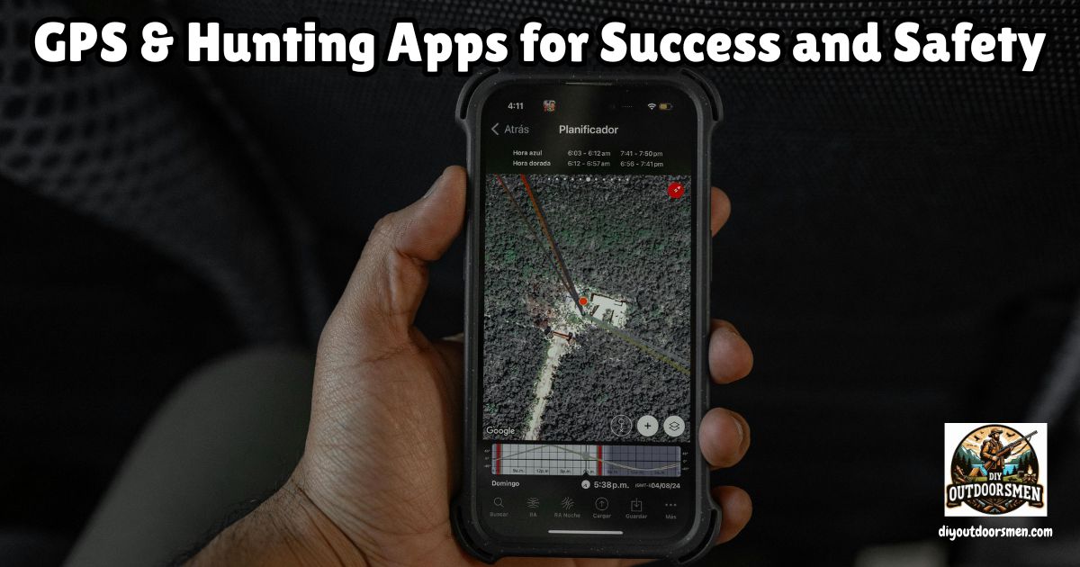
Paper maps and compasses still work, but using GPS units and hunting apps gives me way more options and information on the go. My smartphone, with a solid hunting app installed, or a handheld GPS unit, lets me mark property lines, see my path, and even keep tabs on changing weather. Because of these digital tools, I can plan smarter, stay oriented more easily, and avoid stumbling across posted land by mistake.
Apps like onX Hunt, HuntStand, and Basemap bring a lot of vital information right to my fingertips. I can access different map layers, check property boundaries, and get quick updates about weather and wind.
Instead of relying on memory or scribbled notes, I let these apps remember where I’ve parked, placed stands, or spotted game in previous seasons. Over the years, this data piles up, giving me a stronger game plan each time I hit the field.
While bird hunting or working dogs in dense cover, GPS devices provide added confidence. I track my route, see exactly how far I’ve gone, and always have a reliable way to retrace my steps, no matter how thick the woods get. Learning to use multiple map sources and keeping my own progress tracked has saved me more than once in big timber, where every ridgeline can look confusingly similar.
Pre-Season Scouting and Hunt Planning
Mapping out my hunt before I even leave the house saves loads of time and takes the guesswork out of finding good spots. I like to do plenty of e-scouting online, zooming in on property boundaries and searching for clearings or water sources that could attract wildlife. GPS apps let me drop pins on likely bedding or feeding zones, good trails, or creek crossings, so during boots-on-the-ground scouting, I can check them all out in person without worry.
One of the best things about using hunting apps is their landownership feature, which helps me avoid accidental trespass. I always double-check where public and private land meet. Some platforms even give landowner info, so I can ask for permission before getting close to a property line. This makes the whole process way easier and keeps hunts legal and respectful.
Saving historical data is another big advantage. I track sightings, harvests, and “hot zones” for deer or turkey roosts each year. Over multiple seasons, these digital notes reveal movement trends that help me find spots where activity is highest, based on time of year, weather, and land changes. It takes the pressure off my memory and lets me look up patterns fast when deciding where to hunt next.
Staying Safe and Found in the Field
The most important part of any hunt is being able to get back to my truck or base, no matter the weather or fading daylight. GPS tools and hunting apps with breadcrumb tracking record the exact trail I take. If I have to change plans mid-hunt or exit quickly, I just follow the digital breadcrumb trail back—easy, even in the dark or heavy brush.
Downloading maps for offline use is a must-do before every hunt. Cell service drops off quickly once I leave the main roads, but GPS still works as long as I keep my device powered up. To get more out of my battery, I keep the phone in airplane mode, dim the screen, and always carry a power bank. For longer trips, I pack a backup GPS with fresh batteries, just to be safe.
On group hunts, sharing my live location with others through the app is a huge help. This adds a safety net during deer drives or when tracking wounded game, making it much easier to avoid risky areas and stick to my hunting buddies’ coordinates. Marking no-shoot zones further cuts down on accidents by reminding everyone about safe shooting directions.
Hunting Features That I Use Most
- Offline Maps: I always keep maps of my hunting spots saved locally. Signal loss is no big deal, and I never worry about getting turned around.
- Waypoints: I use waypoints for stand locations, game trails, waterholes, and travel corridors. Returning to these places—even at night—is simple.
- Terrain Layers: Lots of apps include elevation and topographic maps, plus solar angles. They help me picture how animals might move and where to expect wind shifts as the sun rises or sets.
- Property Lines: Avoiding trespass is important, so the detailed boundary info in hunting apps gives me the peace of mind that I’m respecting the rules and neighboring landowners.
- Weather and Wind: Built-in weather feeds show me current wind and changes in conditions, key for picking my setup and approaching quietly.
- Dog Tracking: For bird and raccoon hunting with my dog, GPS collars and synced apps help me keep tabs on my dog’s location, even when I can’t hear the bell in thick woods.
Tips for Using GPS and Hunting Apps Safely
- Keep Basic Skills Sharp: Even though I trust apps, a compass and classic paper map are always in my pack. Electronics can break, get wet, or lose power. Old-school navigation skills are still a must.
- Understand Tech Limits: Phones aren’t as tough as handheld GPS units, so I keep my phone in a waterproof case and try not to rely on it in extreme cold. On long hunts or cold days, I use my GPS for added reliability and battery life.
- Check Data for Accuracy: App property boundaries sometimes show slight errors. Before hunting close to private land, I check local marker signs or official maps and get the facts straight. Following the rules protects everyone.
- Update Maps and Software: Every season, I update my app or GPS with the latest maps. Old data can lead to missed new trails, land changes, or access routes.
Common Questions About Hunting GPS and Hunting Apps
People often ask what type of GPS device or app to use. For quick day hunts, a smartphone app is easy and powerful. Longer or deep-woods hunts call for a tough, battery-friendly GPS unit. Here are a few questions new hunters usually want to know about:
What is the first step for using a hunting app?
Start by downloading your area’s maps for offline use and marking waypoints at parking, stand sites, and possible exit routes. Test out following your breadcrumb trail before depending on it during tough conditions.
How do I keep my phone or GPS from dying in cold weather?
Keep the device warm inside your coat, put it in airplane mode when not using it, and always carry a backup battery or spare AA’s if you’ll be out for a long hunt or overnight trip.
Can I use both phone apps and a standalone GPS while hunting?
You bet. I use my phone for fast reference and quick waypoints, with my GPS as a backup on challenging or longer hunts. Comparing the two is a great way to double-check tracks and locations for the best accuracy.
Best Practices for Consistent Hunting Success
Mixing technology with classic navigation keeps my hunting both effective and safe. By planning my hunts at home, marking and following digital routes, and paying attention to recent animal movement and weather, I keep my hunts efficient and safe.
Every trip adds more info to my records, making future planning that much better. For staying safe and making sure I stay on the right side of property boundaries, hunting apps and GPS devices have become core parts of my gear.
While every hunter’s approach varies, adding GPS units and hunting apps to my regular arsenal has taken both my hunting results and safety up a notch. If you haven’t checked out these tools yet, I highly recommend giving them a try this season—they might just change your adventure for the better.
Most Recent Articles:
- Best Rooftop Tents For Overlanding

- Overlanding The Infamous Black Bear Pass In Colorado

- How To Pack A Lightweight Backpack For DIY Backpack Hunting Trips
- Navigating The Hunt Application Process In The US

- Kodiak Canvas Cabin Lodge Tent

- Safety Tips For Hiking In Bear Country

As always, stay safe, enjoy the journey, and please try to leave it cleaner than you found it. If you have any comments, questions, ideas, or suggestions, please leave them in the comment section below, and I’ll get back to you ASAP. You can follow us on YouTube: Man Art Creations for videos of our DIY Adventures.
P.S. Thanks so much for checking out our blog; we really appreciate it. Just so you know, we may receive a commission if you click on some of the links that appear on our site. This helps us keep our content free and up-to-date for everyone. We appreciate your support!